

An Afternoon in Pisgah on the Spence Ridge Trail
I found myself with an abundance of spare time as I made my way back down to North Carolina for a few weeks. It’s still beautiful out, with sunny skies and weather hovering in the low 80’s. That means that the mountains are cool and the perfect temperature for an afternoon hike (not that I need an excuse to explore).
I love a good day trip and am more than willing to fill up my gas tank countless times for the perfect view. In a quick browse of the internet, I stumbled upon an adventurous little (little?) trail in the Linville Gorge. For those of you not familiar with North Carolina, it’s located in the Pisgah National Forest, which is about 2-2 1/2 hours from Charlotte depending on your traffic situation. Wanting a good hike but not one that would wreck the rest of my day, the general consensus was that the Spence Ridge Trail was easy enough, and lead to a spectacular view.
First – there are too many people who need to look up the definition of “easy.”
Second – the view was indeed, spectacular.
Locating the Trail
The main article I had found gave really great directions on how to locate the trail. They had mentioned that the road down to the trailhead was gravel and that it is not suitable for low laying cars. That is absolutely correct! As a recovering Jeepaholic now driving a Toyota RAV4 (which is a nice little SUV), the human-sized potholes even made me nervous. The road down was bumpy to say the very least. I highly recommend you bribe a friend to go with you if you don’t own an SUV. But if your friends are hermits and sparkle in the daylight, then may the odds be ever in your favor – drive slow.
finding the right path
Once you reach the trailhead, there is a sign that says Linville Gorge Wilderness. You’ll want to start along that trail and not the one that veers off to the left by the road. It’s a little bit of a walk as you get going and it’s pretty easy. You’ll eventually come to a fork so-to-speak. You can continue straight or make a sharp right turn and head down that direction. Take the sharp right.
Now before I go much further, there are some important details I’d like to make note of.
Know Before You Go
First, on the entire drive down once I reached the forest, I did not see a restroom. To be fair, I had a destination and was intent on not missing my turns, as I have a habit of doing. Perhaps there are restrooms located somewhere in the vicinity of the forest, but none were in my line of sight and not even at the trailhead, that I could locate.
Second, I would not recommend hiking with your fur baby unless you know for certain that they can handle an incline. I have hiked with a very adventurous little Yorkie that never says “no”, and I would have been cautious about taking her. As I mentioned earlier, “easy” is not a term I would use to describe this hike. There is a pretty significant decline in elevation along the trail, which can only mean that the way back will make you as breathless as eating Thanksgiving dinner. There are tons of roots and rocks to navigate around. If you’re a little unsteady, I would recommend some trekking poles. For me personally, I do not like to have anything in my hands as I go, which is difficult as a photographer. But your legs will thank you on the way back up.
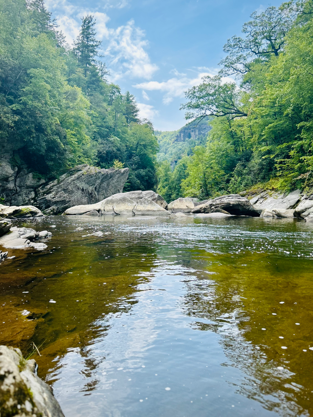
Now, the Spence Ridge Trail is an almost 3 mile hike round trip. Depending on how long you stay at the river, it’s an average of an hour and 45 mins from start to finish. The forest is pretty and I didn’t encounter much traffic along the trail, but it isn’t the most entertaining of hikes. It also isn’t marked. A lot of trails will have a colored marker of some sort on the trees as you go to identify which one you’re on, but this one did not. So if you’re adventurous like me (but with a better sense of direction), I recommend not veering too far off course. The stream becomes noticeable the further down you go, giving you little glimpses of what’s to come. The final destination however, is worth every cob web you can’t get off of your face.
The trail opens up to a truly Instagram worthy view. Large boulders beckon you to sit and enjoy your lunch or a snack. The water is cool and clear (we’re talking mid September). I did not take a dip, but if you like to get a little wet on your adventures, the water was calm enough for a swim. It’s also maybe not the safest place to have your pet, as currents can be unpredictable in wild waters. Please use extreme caution if you have your pup with you.
As someone who likes to create “cool things,” I took my drone with me and was NOT disappointed. The aerial view was breathtaking. It was an absolutely gorgeous day and Mother Nature shone bright in all of her glory.
As I made my way back up, the incline was immediately noticeable. My legs were still a little shaky from the hike down, so going back up was slow moving. I highly recommend plenty of water and stops along the way as you need. You are the only one who knows how hard you’re capable of being pushed. Don’t be a hero.
If you’re in western North Carolina and are looking for a social media drool fest, a day trip adventure, or just a little tranquility, the Spence Ridge Trail is definitely worth the drive and effort.
Click here to download my favorite trail app.


Leave a comment